Climate change threats to seagrass, mangrove and saltmarsh
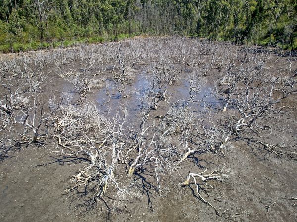
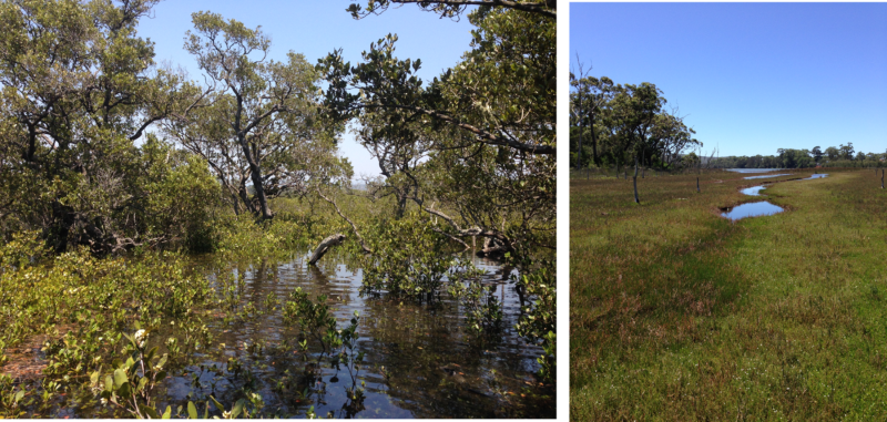 Mangrove (A) and saltmarsh (B) are vital for the ecology, productivity and protection NSW estuaries but are under threat from the impact of climate change including sea level rise.
Overview
Why is this project important?
Mangroves and saltmarsh are critically important to the healthy function of NSW estuaries. They provide many benefits to our estuaries including improving water quality, flood mitigation and bank stabilisation, as well as providing essential habitat for important recreational and commercial fisheries and serving as a highly efficient carbon sink.
The ability of mangroves and saltmarsh to protect estuary banks and infrastructure from erosion from storms, wave action and flood events will prove increasingly important to protecting coastal settlements from the increase in frequency of extreme weather events due to climate change.
Over the past two centuries of coastal zone development in NSW, mangroves and saltmarsh have been under pressure from clearing, drainage and reclamation, and inappropriate use.
The mangrove and saltmarsh wetlands remaining across our NSW coast are facing new pressures from current and future climate change.
These climate change related pressures include sea level rise, changing catchment hydrology (flooding and droughts), and evolving estuary entrance conditions.
You can find out more about mangroves and saltmarsh and climate change in Australia here.
What are we doing?
In response to these emerging threats to mangroves and saltmarsh, we are undertaking assessments of the vulnerability of these important ecosystems to sea level rise and climate change across NSW to identify estuaries most at risk. This will inform a prioritisation of efforts to help mangrove and saltmarsh areas adapt to climate change.
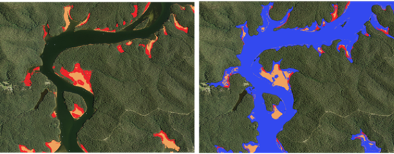
The images below show current mapped areas of mangrove and saltmarsh (A) in the Clyde River adjacent to a map of projected mangrove and saltmarsh areas following a sea level rise of 1 m (B).
Mangroves are shown as yellow and saltmarsh is red in these 2 images.
Mangrove and saltmarsh response to sea level rise and climate change is variable, so choosing the appropriate management actions to assist critically important wetlands to adapt can be complex.
We are also developing models for wetland response to sea level rise and climate change pressures in NSW. These models will help conservation and land managers make more informed management decisions that will assist wetlands to adapt.
What have we achieved so far?
We have completed an assessment of mangrove and saltmarsh vulnerability to sea level rise across NSW.
This assessment identifies areas where mangroves and saltmarsh will likely be lost as sea levels rise and areas where mangroves and saltmarsh may be able to move inland with appropriate management. The assessment considers three future sea level rise scenarios and two land use scenarios.
Maps of future projections of mangrove and saltmarsh under these scenarios are available on the NSW Seed Portal.
A full description of the methods used for the state-wide mangrove and saltmarsh vulnerability assessment is available here.
Read the paper on the state-wide mangrove and saltmarsh vulnerability assessment here.
Locations
Statewide
Local government areas - Statewide
Lead agency
NSW Department of Climate Change, Energy, the Environment and Water (NSW DCCEEW)
Partners
NSW Department of Primary Industries - Fisheries
More information
- Maps of future projections of mangrove and saltmarsh under these scenarios are available on the https://datasets.seed.nsw.gov.au/dataset/projected-distribution-of-mangrove-and-saltmarsh-in-nsw-estuaries-under-sea-level-rise
- A full description of the methods used for the state-wide mangrove and saltmarsh vulnerability assessment is available here: https://www.frontiersin.org/articles/10.3389/fenvs.2022.749950/full
- Read the paper on the state-wide mangrove and saltmarsh vulnerability assessment here:
- https://www.sciencedirect.com/science/article/pii/S0048969722075854?via%3Dihub
- NSW Primefacts - Mangroves
- NSW Primefacts - Coastal saltmarsh