Subtidal reef monitoring
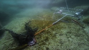 A baited remote underwater video system to gather data on the size, diversity and abundance of fishes on subtidal reefs. Photo by: Nathan Knott.
Overview
Why is this project important?
Coastal reefs and underwater rock formations are important marine habitats. They support a wide variety of animals and plants, including many fish species targeted by recreational and commercial fishers.
In NSW these habitats are under increasing pressure from a range of threats including water pollution, coastal development and climate change.
Monitoring the health of these habitats is critical to identify impacts and guide activities to manage the threats.
What are we doing?
We are working to better understand life on coastal reefs and deep rocky reefs in the Greater Sydney Region (from Newcastle to Shell Harbour). To do this we are surveying the rocky reefs across the area to determine:
- the different types, numbers and size of fish in these areas
- the distribution of key habitat species, such as kelp and sponge gardens.
These surveys are being conducted using baited remote underwater video surveys (BRUVS). You can see some footage from our BRUVS by clicking on the link on the right.
We are also undertaking remotely operated vehicle surveys of the biodiversity of the coastal reefs in our NSW aquatic reserves.
Project results will provide managers with new scientific information to support and inform management of these important coastal reefs systems. Project data will also contribute to the Marine Integrated Monitoring Program.
What have we achieved so far?
- Conducted surveys on over 350 sites for reef fishes and habitats using baited remote underwater videos in the Greater Sydney region. Surveys were done in 2019 and 2022.
- Biodiversity surveys in 10 Aquatic Reserves using a remotely operated vehicle.
- Published Maps of juvenile and adult snapper distributions in journal – Estuarine, Coastal and Shelf Science.
- Published a paper on the impacts of extreme flooding to reef fishes in the journal Ecology. The research findings will help fisheries managers understand and prepare for the effects of extreme floods in the future.
- Completed diver surveys at 22 sites in Jervis Bay Marine Park which measured reef biodiversity, including the sizes and abundances of fish and large invertebrates (e.g. lobster, abalone, sea stars, urchins), as well as algae (e.g. kelp) and smaller invertebrates (e.g. barnacles, urchins, sponges). The data will be used to monitor indicators of reef biodiversity through time.
We completed Abalone surveys offshore of Eden and surrounding area. The data will support Fisheries Compliance in targeting illegal fishing and provide a contemporary baseline of abalone size and density in a remote part of southeastern Australia, helping to guide future stock management.
Fish data collected using baited remote underwater video systems in the central and southern regions, were included in the recently published NSW State of the Environment report.
Diver-based subtidal reef biodiversity surveys were carried out from Batemans Bay to Narooma, including Montague Island, to build a clearer picture of reef condition across the region.
For more information about our achievements in Marine Estate Management Strategy, please visit our report page.
Locations
Greater Sydney region coastline from Newcastle in the north to Shellharbour in the south
Local government areas - Statewide
Lead agency
- DPIRD Fisheries
Our Initiatives
Contacts
Project updates
Case study: Subtidal reef monitoring
2 December 2025
