Domestic waterfront structure strategies
Overview
What are Domestic Waterfront Structure Strategies?
Many people dream of owning a coastal waterfront property where they can build their own jetty or pontoon.
However, building new waterfront structures such as jetties, pontoons and boat ramps can impact waterway users and the environment.
Because of this, private landholders need to obtain approval or landowner’s consent (LOC) to build these structures on land adjoining their waterfront properties in estuaries across NSW.
Until now, consent for requests to build waterfront structures was individually assessed by various NSW Government agencies, causing double handling and costly inefficiencies.
This project aims to simplify this by creating estuary-wide plans called Domestic Waterfront Structure Strategies.
Domestic Waterfront Structure Strategies are new online maps that show the suitability of waterfront areas for building waterfront structures in different parts of an estuary.
They have been created by assessing the suitability of riverfront areas for installing jetties, boat ramps or pontoons based on who owns the land and its social and environmental value.
Watch the video above to find out more about how developing Domestic Waterfront Structure Strategies will reduce red tape for building waterfront structures in NSW estuaries.
A traffic light system
GREEN: Suitable for an application for LOC to build a waterfront structure. You can submit LOC applications to DPE-Crown Lands without referral letters from other agencies.
ORANGE: Further assessment is required before applying for LOC to build a waterfront structure.
RED: unsuitable for gaining LOC to build a waterfront structure.
Likewise, people deciding whether to purchase waterfront land can see in advance if an area has been pre-assessed as 'red' and hence building a jetty, boat ramp or pontoon will not be allowed in the future.
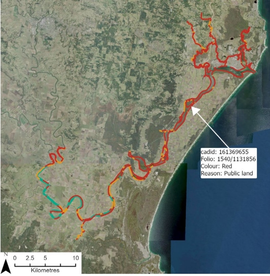
To improve public awareness, reasons why areas are marked as red or orange are included in the mapping.
Look at the table under 'locations' below to see if the Domestic Waterfront Structures Strategy for your estuary is available yet, or when they will become available.
Locations
Table 1: Status of Domestic Waterfront Structures Strategy for NSW estuaries to date.
| Completed Domestic Waterfront Structures Strategy | Domestic Waterfront Structures Strategies Underway |
|---|---|
| Cape Byron Marine Park (PDF, 4205.02 KB) | Lake Macquarie |
| Richmond River estuary (PDF, 2315.08 KB) | Port Stephens Great Lakes Marine Park |
| Evans River estuary (PDF, 5200.59 KB) | Clarence River |
| Tweed River estuary (PDF, 7412.38 KB) | Lake Conjola |
| Shoalhaven / Crookhaven River estuary (PDF, 6382.08 KB) | Wonboyn Lake |
| Lake Illawarra estuary (PDF, 4798.84 KB) | |
| St Georges Basin estuary (PDF, 4858.99 KB) | |
| Burrill Lake estuary (PDF, 4922.65 KB) | |
| Jervis Bay Marine Park (PDF, 6802.98 KB) | |
| Batemans Marine Park – North (PDF, 6982.13 KB) | |
| Batemans Marine Park – South (PDF, 6341.75 KB) | |
| Bermagui River, Cuttagee Lake and Murrah River (PDF, 6649.96 KB) | |
| Curalo Lagoon, Nullica River and Towamba River (PDF, 4750.17 KB) | |
| Merimbula Lake and Back Lagoon (PDF, 6610.19 KB) | |
| Pambula River (PDF, 6532.68 KB) |
Available maps which show suitable and unsuitable waterfront areas for landowners' consent, along with the reason why they are either suitable or unsuitable are available via the Fisheries Spatial Data Portal. These will be progressively uploaded to the FSDP as the strategies are made available for priority estuaries.
More Domestic Waterfront Structures Strategies will be added to this page as the project progresses.
Local government areas - Ballina Shire Council, Byron Shire Council, Eurobodalla Shire Council, Lismore City Council, Richmond Valley Council, Shellharbour City Council, Tweed Shire Council, Wollongong City Council
Lead agency
Department of Primary Industries and Regional Development Fisheries
Partners
- Local Councils
- Department of Planning, Housing and Infrastructure - Crown Lands
- Department of Planning, Housing and Infrastructure - Planning
- Transport for NSW
- NSW Department of Planning and Environment, Natural Resources Access Regulator
NSW Department of Climate Change, Energy, the Environment and Water (NSW DCCEEW)